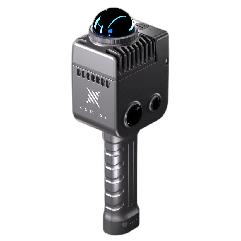
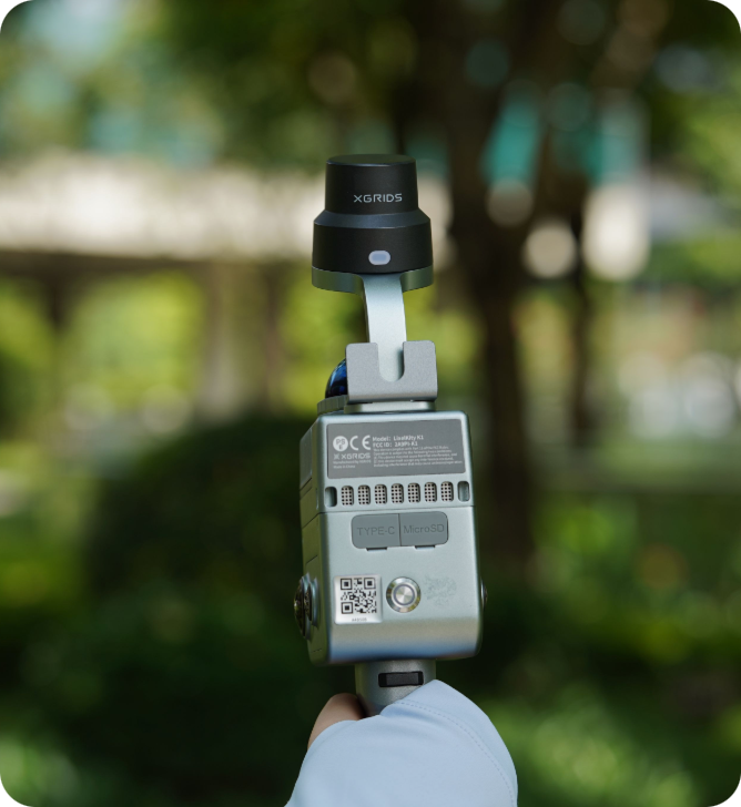
XGRIDS LixelKity K1 Compact Yet Powerful · 3D Modeling as Simple as a Stroll
Compact handheld SLAM LiDAR scanner — real-time colorized point clouds from 48 MP × 2 panoramic vision and Multi-SLAM AI, in a 1 kg body you carry anywhere.
One button starts the scan. Walk at a natural pace and the K1 builds a centimeter-accurate, true-color 3D model in real time — 200,000 points per second from a 40-line 360° LiDAR, colorized on-device by dual 48 MP panoramic cameras. No tripod, no targets, no specialist operator, and a direct path from point cloud to photorealistic 3D Gaussian Splatting. Full specifications →
Rev1 Technologies is the authorized North American distributor for XGRIDS Lixel scanners — pre-sales consultation, application support, and post-purchase assistance from Auburn Hills, MI. Questions? Call (248) 707-2950.
Your Authorized XGRIDS Source in North America.
Rev1 Technologies is the authorized North American distributor for the XGRIDS Lixel scanner lineup. Pre-sales consultation, application engineering, training, and post-purchase support are delivered from Auburn Hills, Michigan — with US stock and free US shipping.
Compact, Powerful, and Precise — Professional SLAM for Everyone

A 360° LiDAR, Four Cameras, and an AI Brain — in One Hand
The K1 packs a 40-line 360° LiDAR, a four-camera panoramic vision module, and XGRIDS Multi-SLAM AI into a navigational-aluminum body weighing just 1 kg with battery. It generates rich-colored, finely detailed 3D models with unmatched ease and speed — professional spatial capture at a consumer-accessible price.
Centimeter-level relative accuracy (3 cm absolute) for as-built surveys, property documentation, and digital twins — no tripod, no specialist operator.
Dual 48 MP panoramic cameras deliver genuine 360° × 360° color coverage — every point cloud is vivid, detailed, and presentation-ready.
Forty laser lines sweep a full 360° horizontal field of view, densely covering rooms, corridors, and facades in a single pass.
40 m working range at 10% reflectivity, extending to 70 m on bright surfaces — atriums, warehouses, and open terrain without repositioning.
Dust-protected and splash-resistant from -20°C to 50°C. Backpack it through rugged terrain, dusty sites, and light rain.
Scan data flows straight into Lixel CyberColor for photorealistic 3D Gaussian Splatting — shareable, VR-ready spatial models.
Pick It Up, Walk, and Scan
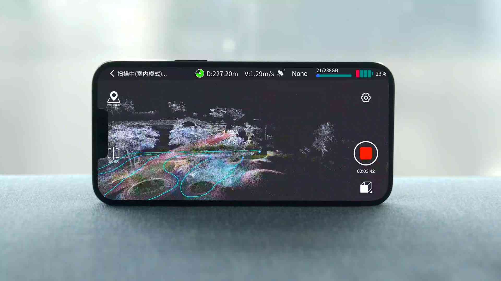
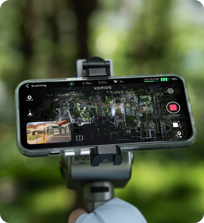
The K1 reduces 3D scanning to its simplest form — one button, a natural walking pace, and a live model on your phone.
One Button. No Tripod. No Targets.
Press once and walk. The K1 tracks its own position with Multi-SLAM while building a centimeter-accurate colored model in real time — watch it grow on the LixelGO app as you move. The fast-lock magnetic battery swaps in seconds for long site visits, and resume-from-breakpoint picks the scan up exactly where you stopped.
Real-Time Modeling, Vivid Reconstruction
True-Color Point Clouds From the First Pass
The 40-line LiDAR streams 200,000 points per second while the dual 48 MP panoramic cameras fuse color onto the cloud on-device — no separate colorization step, no post-processing wait. Review the live model during capture, catch missing coverage before you leave, and walk off site with complete data the first time.
Upgraded Multi-SLAM — Stable Capture Anywhere
Laser + Vision + GNSS, Fused by AI
Single-sensor SLAM drifts in dark corridors, feature-sparse rooms, and open terrain. The K1’s Multi-SLAM algorithm fuses the LiDAR loop, panoramic visual odometry, and GNSS-aided positioning into one drift-resistant solution — with visual-aided positioning supported out of the box and survey-grade absolute coordinates available through the optional RTK module.
Unlock the Cyber World — Point Cloud to Photorealistic
The K1 is the entry point to the XGRIDS spatial intelligence pipeline — from survey-ready point clouds to shareable, VR-ready 3DGS scenes.
CyberColor: 3DGS With 90% Smaller Files
Feed K1 scan data into Lixel CyberColor and AI generates photorealistic 3D Gaussian Splatting models in the compact LCC format — roughly 90% smaller than raw equivalents. Capture vegetation, interiors, and full sites in lifelike detail, then render on screen, share in a browser, or walk through in VR.

Photorealism You Can Walk Through
This library interior is a 3DGS reconstruction from K1 scan data — not a photograph. Every shelf, spine, and light fixture renders in real time in a browser or VR headset. For BIM teams, the LCC for Revit plugin brings the same scenes directly into Autodesk Revit modeling workflows.
Why the K1 Outperforms Traditional Methods
Tripod scanning means days on-site, specialist operators, and weeks of post-processing. Real teams measured what changed when they switched.
“We reduced our scanning time from 8 hours to 17 minutes per floor. The point cloud quality meets all our architectural modeling requirements… time is money!” — Ben Stocker, Senior Construction Technologist, Skender. Preconstruction documentation that took 5+ days now turns around in hours.
“The equipment is lightweight and durable enough for remote environments, fitting in a backpack… just a button press to begin capturing 3D data.” — Carlos Bausa Martinez, Founder, ArquiaVis.
Live review on the LixelGO app means coverage gaps get filled before you leave — no re-mobilization, no second site day, no waiting to find out.
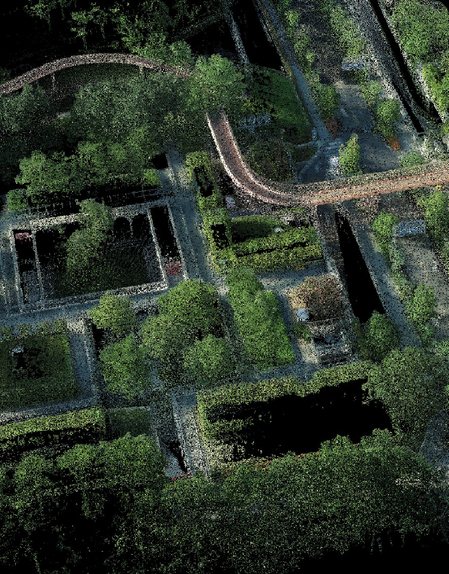
A Full Park, One Walk
Walkways, bridges, and vegetation captured at centimeter detail in a single stroll-through session — the kind of site documentation that previously demanded a tripod crew and multiple setups. From forestry management and topographic survey to real estate and forensics, six industry verticals run on exactly this workflow.
One Platform From Field Capture to CAD Deliverable
Three XGRIDS tools cover the entire pipeline — LixelGO in the field, LixelStudio at the desk, CyberColor for photorealistic delivery.
LixelStudio — Measure, Edit, Export
Import K1 data into LixelStudio for professional point cloud processing: on-screen measurement, colorization, leveling, edge filtering, mesh generation, and structured export into CAD and AEC workflows. The construction-site clip here shows live dimension takeoffs running directly on K1 field data.
Real-time scanner control, mission planning, and live model monitoring on your phone — 20 m Wi-Fi working distance from the scanner.
Windows post-processing suite included with the K1 — measurement, editing, meshing, and export to standard point cloud formats.
AI-powered photorealistic scene generation with ~90% file-size reduction — the same engine behind XGRIDS digital-twin deliverables.
Scan → Process → Deliver. Hours, Not Days.
Three Steps to a Client-Ready Model
There is no calibration ritual and no target layout. The K1’s workflow is deliberately short, so the bottleneck is never the scanner.
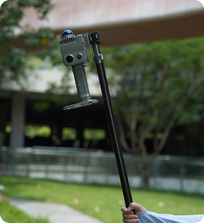
Expand What You Can Capture
Three optional accessories extend the K1 from compact mapper to survey-grade, elevated, hands-free capture rig.
Explore the K1 and Its Point Clouds — Rotate Them Yourself
Community-published 3D models of the LixelKity K1 inside its own captured data — spin, zoom, and inspect how the scanner sees the world.
LixelKity K1 vs. GeoSLAM ZEB Go vs. Leica BLK2GO Pulse
Buyers shopping handheld SLAM compare the K1 against the entry-tier ZEB Go and the premium BLK2GO Pulse. Here is the honest breakdown — including budget.
| Capability | XGRIDS LixelKity K1 | GeoSLAM ZEB Go | Leica BLK2GO Pulse |
|---|---|---|---|
| Price (USD) | $12,499 — free US shipping | ~$22,000+ | ~$35,000+ |
| Point rate | 200,000 pts/s | 43,000 pts/s | 600,000 pts/s |
| Relative accuracy | 1.2 cm SLAM | 1–3 cm | 10–20 mm |
| Colorization | 48 MP × 2 panoramic — on-device, real time | External camera accessory required | Built-in 360° HDR imaging |
| 3D Gaussian Splatting | Native via Lixel CyberColor | No 3DGS workflow | No native 3DGS |
| Geo-referencing | RTK module supported (accessory) | Post-processed control | Leica ecosystem workflows |
| Weight | 1 kg with battery | ~1 kg + cabled datalogger pack | ~775 g handheld |
| US partner support | Rev1 Technologies — phone support, training, demos (Auburn Hills, MI) | Dealer network | Leica dealer network |
Competitor figures are approximate, from publicly available manufacturer information, and vary by configuration; provided by Rev1 Technologies for general orientation. At $12,499 the K1 is the only scanner in this group with true dual 48 MP panoramic colorization and a native 3D Gaussian Splatting pipeline — roughly half the budget of the ZEB Go class and a third of the BLK2GO Pulse, with free US shipping.
XGRIDS LixelKity K1 Technical Data
Specifications from the official XGRIDS LixelKity K1 parameter sheet. Accuracy measured under standard laboratory and field conditions; actual performance varies with environment, GNSS availability, and scan configuration. Contact Rev1 for project-specific guidance.
RESOURCES
Downloads & Technical Support
Everything you need to evaluate and run your LixelKity K1 with confidence. Explore the full Rev1 3D scanning range.
WHY REV1 TECH
Authorized XGRIDS Distributor. Reality-Capture Specialists.
Rev1 Technologies is headquartered in Auburn Hills, MI, with direct expertise in mobile mapping, SLAM, and reality capture.
Rev1 carries the full XGRIDS lineup — Lixel K2, Lixel L2 Pro, PortalCam, and the CyberColor software stack. We don’t just ship boxes: we validate your application, train your team, and support the system for its working life.
LixelKity K1 — questions buyers ask before ordering.
REV1 TECHNOLOGIES