XGRIDSLixel L2 ProHandheld SLAM LiDAR Scanner
A 1.7 kg handheld SLAM LiDAR scanner that delivers post-processed-quality colored point clouds in real time — sub-1 cm relative and 3 cm RMS absolute accuracy, from handheld to backpack, vehicle, and drone.
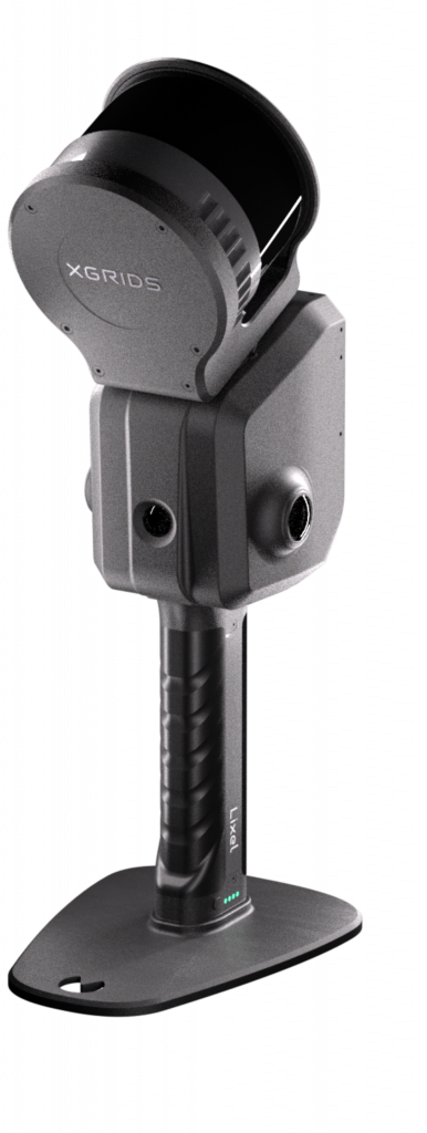
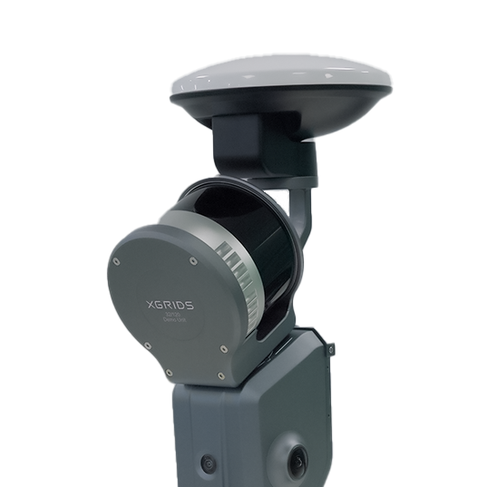
The XGRIDS Lixel L2 Pro is a 1.7 kg handheld SLAM LiDAR scanner that delivers post-processed-quality colored point clouds in real time. Multi-SLAM AI fuses LiDAR, dual 48MP panoramic vision, and a 500 Hz IMU on-device for sub-1 cm relative and 3 cm RMS absolute accuracy. IP54 industrial aluminium body, 1 TB built-in SSD, and four deployment modes — handheld, backpack, vehicle, and drone. Outputs LAS / LAZ / E57 / PLY plus 3D Gaussian Splat. Full specifications →
Rev1 validates application fit, variant selection, RTK strategy, deployment mode, and software workflow before purchase. Authorized XGRIDS partner in the USA — Auburn Hills, MI. Questions before you quote? Call Rev1 at (248) 707-2950.
Factory-Built Precision. US-Supported by Rev1.
The Lixel L2 Pro is genuine XGRIDS hardware, sold and supported in the United States by Rev1 Technologies. A survey-grade handheld SLAM scanner is a workflow decision, not just a hardware purchase — Rev1 validates the variant, RTK strategy, deployment mode, and software stack before deployment, and supports it after.
Post-Processed Quality — In Real Time
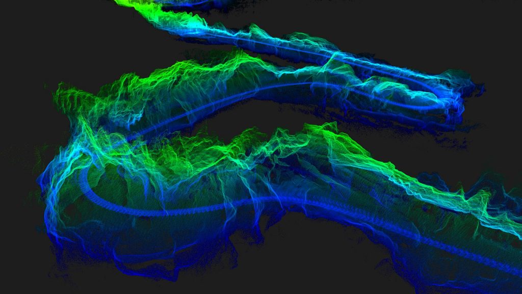
Handheld SLAM scanners usually trade accuracy for portability. The L2 Pro keeps both. Multi-SLAM AI fuses LiDAR, dual 48MP panoramic vision, and a 500 Hz IMU into a single colored point-cloud stream — survey-grade geometry and photographic color, the moment the operator stops walking.
Survey-grade cloud, photoreal color, on-device
The L2 Pro generates a real-time colored point cloud at acquisition time — no overnight batch step before the field crew can review results. Real-time absolute accuracy holds to 3 cm RMS even when RTK disconnects within 100 m, and relative accuracy stays sub-1 cm between any two points within 100 m. LixelUpSample densifies output to one million points per square metre at 1 mm spacing, with post-processed cloud thickness reduced to 5 mm.

One scanner. Indoor walkthroughs to aerial surveys.
At 1.7 kg without battery, IP54-rated, with a 1 TB built-in SSD and four deployment modes, the L2 Pro covers indoor walkthroughs, large outdoor surveys, mobile mapping, and aerial capture — without a separate hardware purchase per mode. From cold start to colored point cloud in a single walkthrough, with no post-processing wait.
Power On. Walk the Site. Watch the Cloud Build.
The L2 Pro is engineered for single-operator workflows. There is no laptop tether and no stop-and-shoot cycle — the scanner streams a colored point cloud, IMU pose, and panoramic color into one fused stream on-device while you walk.
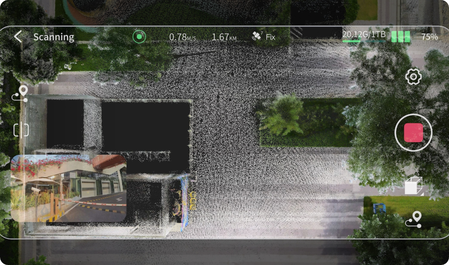
One-touch start, live point cloud preview
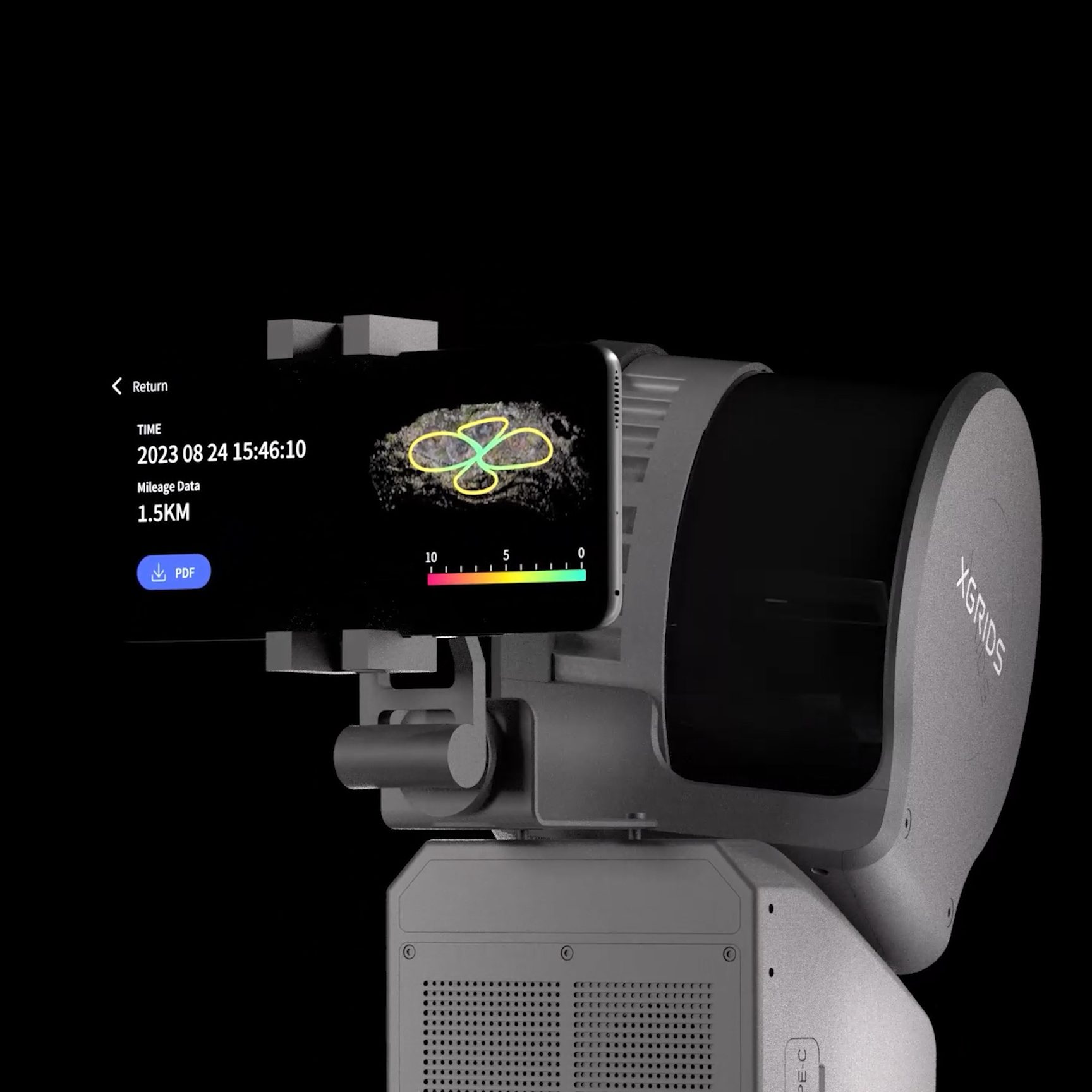
The LixelGo app on your phone provides live point-cloud preview, elevation display, RTK status, and one-click control-point capture — over USB-C or Wi-Fi. You see coverage, density, and RTK lock as you walk, so gaps get caught on site instead of back in the office. The loop from acquisition to client review collapses from days to minutes.
Field-usable deliverables before you leave site
Traditional SLAM workflows require overnight processing before a field crew can review results. The L2 Pro produces the real-time colored cloud at acquisition time, with the option to refine in Lixel Studio 3.0 for higher density, mesh generation, or 3DGS export. The downstream loop — first-pass deliverable, client review, recapture decision — now happens before the crew leaves the site.
3 cm RMS Absolute. <1 cm Relative. Up to 300 m.
RTK-fused under open sky to 1 cm + 1 ppm horizontal; held to 3 cm RMS by Multi-SLAM continuity within 100 m of the last RTK fix. The sensor fusion preserves the cloud across the failure modes that destroy lesser scanners.
The range upgrade does not compromise geometry
Relative accuracy is sub-1 cm between any two points within 100 m, identical across all three variants. The 32-channel 300 m variant pushes range to 300 m for open-pit mining, road corridors, and large outdoor sites — while 16/120 and 32/120 cover indoor and medium-range envelopes. More than 1.5 km accumulates in a single continuous session without re-anchor.
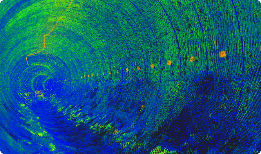
GPS-denied continuity, underground and indoors
Multi-SLAM fuses LiDAR, visual positioning, and the 500 Hz IMU to hold absolute coordinates in tunnels, underground utilities, basements, and dense interiors when RTK is unavailable — re-anchoring against RTK whenever GNSS coverage returns. For projects entirely underground, control points at known coordinates anchor absolute positioning.
Multi-SLAM AI: LiDAR + Visual + IMU, Fused On-Device
Multi-SLAM is the L2 Pro’s joint-optimisation algorithm. It runs LiDAR, dual 48MP panoramic vision, and a 500 Hz IMU through a single fusion pipeline, on-device, in real time — the reason real-time output matches post-processed quality.
Continuous absolute coordinates, every environment
The combined sensor stack maintains continuous absolute coordinates where any single signal would lose lock — tunnels, basements, dense urban canyons, and building interiors — and re-anchors against RTK whenever GNSS coverage returns, not selected per pass. A 500 Hz IMU with 0.5 deg/h gyro bias instability holds coordinate continuity across rapid motion, stair turns, and aerial transit. Sensor fusion runs locally: no upload latency, no proprietary cloud subscription, no data-residency surprise.
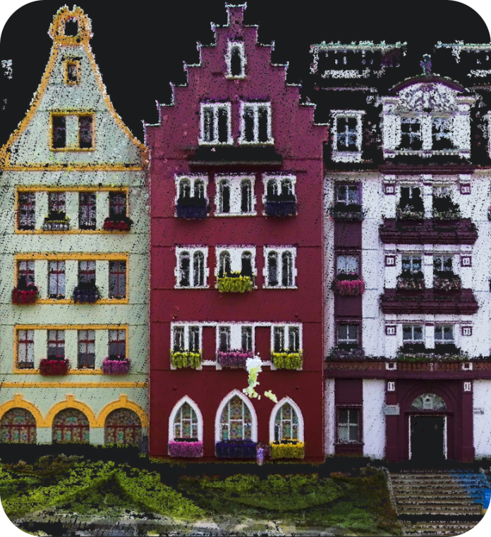
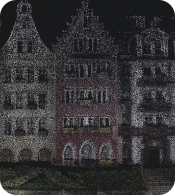
Dual 48MP Panoramic Cameras. Photoreal Color, Every Scan.
Two 48-megapixel panoramic cameras, each with a 190°×190° field of view, combine for a full 360°×270° envelope. Cameras are calibrated to LiDAR origin at the millimetre level, so color attaches to point geometry without the misregistration that plagues retrofit color-mapping pipelines.

True RGB on every point, at acquisition time
Every point in the cloud carries true RGB the moment it is captured — no second pass, no manual alignment. The dual-camera stack stays locked to LiDAR geometry, so fine detail, fabric, foliage, and intricate surface texture survive into the deliverable rather than washing out.
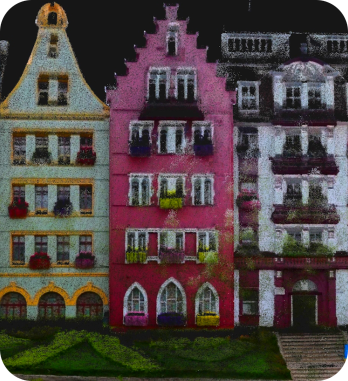
Gaussian Splat via LixelCyberColor
LixelCyberColor takes the dual-camera color stream and the LiDAR cloud and generates 3D Gaussian Splat deliverables compatible with Unity, Unreal Engine, web platforms, and the LCC for Revit BIM plugin. The same field session that produces the survey-grade point cloud produces the photoreal digital twin — so BIM as-built, stockpile volume, digital-twin, and scout-and-recapture workflows all start hours sooner.
1.7 kg. IP54. 1 TB SSD. Built for the Field.
An industrial aluminium body built for one-handed operation across confined, outdoor, and field-rugged environments — from dusty job sites to light rain and broad temperature swings.

Field-grade body, all-day storage
At 1.7 kg without battery and 180 × 130 × 400 mm, the L2 Pro is built for one-handed operation without operator fatigue. IP54 ingress protection and a -20 °C to 50 °C operating range handle real survey conditions, while the built-in 1 TB SSD captures continuously across multi-hour sessions — no field laptop tether, no hot-swap card workflow.
Eye-safe LiDAR, swappable power
A 905 nm Class 1 eye-safe laser meets standard regulatory requirements for use around personnel without protective equipment. The 47.5 Wh swappable battery runs 150 minutes per charge at 16 W; the Premium package adds a second battery for roughly three hours of continuous field time. USB 3.1 Gen 2 plus Wi-Fi and Bluetooth connect the device for direct phone control, file transfer, and live LixelGo display.
One Scanner. Four Deployment Modes.
Switch the same L2 Pro body between handheld walkthroughs, elevated pole capture, vehicle-mounted mobile LiDAR at up to 40 km/h, and DJI M300/M350 RTK drone surveys. The deployment mode is a configuration choice, not a hardware procurement.

Handheld
Single-operator indoor and outdoor surveys with phone-mounted live LixelGo preview and 150 minutes of field time per battery. The core deployment for building documentation, utilities, and confined spaces.
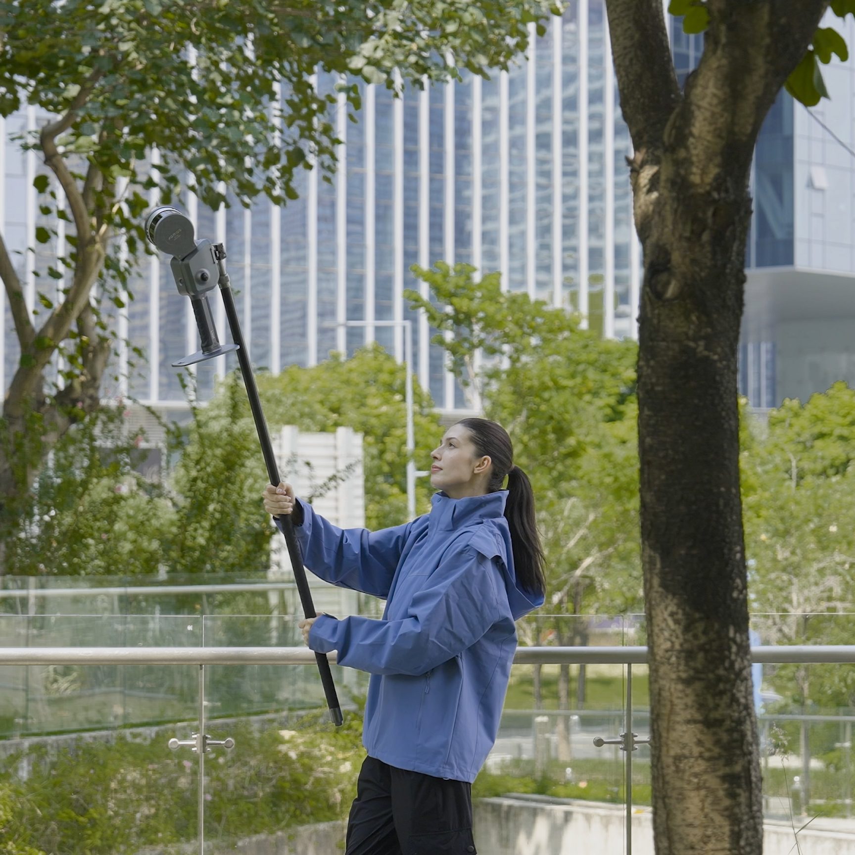
Extension pole
A 2 m or 3 m pole mount reaches over obstructions, into stairwells, and across high-clearance spans — elevated and confined-space capture without ladder access.
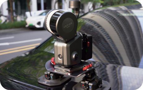
Vehicle & drone
A suction roof mount enables road-corridor mapping and large-area mobile LiDAR at up to 40 km/h with live point-cloud preview. The drone bracket fits the DJI Matrice 300 RTK and Matrice 350 RTK for aerial capture — approximately 6 cm absolute and 2 cm relative airborne — with no separate aerial scanner to buy.
Lixel L2 Pro vs. Competing Handheld SLAM Scanners
Buyers cross-shop the L2 Pro against the industry-default benchmark, the closest-priced peer, and the premium-tier reference. Here is where imaging fidelity, deployment flexibility, and software openness separate them — competitor street prices shown honestly (~).
| Capability | XGRIDS Lixel L2 Pro | GeoSLAM ZEB Horizon | Stonex X120GO | Leica BLK2GO |
|---|---|---|---|---|
| Real-time output | Post-processed-quality, on-device | Basic; office step required | Limited real-time fidelity | Real-time, proprietary stack |
| Imaging | 2 × 48MP panoramic, 190°×190° | Lower-resolution | Lower-resolution | Panoramic, lower MP |
| 3D Gaussian Splat | Yes — LixelCyberColor | No | No | No |
| Deployment | Handheld + harness + vehicle (40 km/h) + DJI drone | Handheld only | Handheld only | Handheld only |
| Output formats | LAS, LAZ, E57, PLY, glTF, USDZ (open) | Mostly closed ecosystem | Open formats | Proprietary + e57/las |
| Street price (~) | Best value — request quote | ~$42,167 | ~$29,995 | ~$55,945 |
| Best fit | Real-time colored cloud + vehicle/drone + open export, in one purchase | Standardised on that vendor’s ecosystem | Budget handheld, no aerial/3DGS | Premium-tier handheld inside that vendor’s stack |
XGRIDS Lixel L2 Pro Technical Data
RESOURCES
Downloads & Technical Support
Everything you need to qualify and run your XGRIDS Lixel L2 Pro with confidence.
WHY REV1 TECH
Authorized XGRIDS Reseller. Reality-Capture Specialists.
Rev1 Technologies is headquartered in Auburn Hills, MI, with direct expertise in mobile mapping, SLAM, and reality capture. Buying through Rev1 pairs the L2 Pro with US-based application review and support — not a direct-import crate with no workflow ownership.
Lixel L2 Pro Buyer Questions
Which Lixel L2 Pro variant should I choose: 16/120, 32/120, or 32/300?
The 16-channel 120 m variant covers most indoor and medium-range outdoor applications at the lowest entry price — building documentation, utilities, confined spaces, and sites under 120 m. The 32-channel 120 m doubles point density to 640,000 pts/s for fine surface detail. The 32-channel 300 m is for large outdoor sites, open-pit mining, road-corridor mapping, and any project where scan range is the binding constraint. Rev1 will match the right variant during the quote process.
What is the difference between the Standard and Premium packages?
The key difference is a second handheld battery in Premium — extending field time from about 1.5 hours to roughly 3 hours between charges. Both packages include the same core hardware: scanner, battery, phone mount, charger, GCP collection plate, protective cover, USB-C cable, and protective case. The 32/300 variant is only available as Premium.
Does the L2 Pro work indoors and underground without GPS?
Yes — this is a core design requirement. Multi-SLAM fuses LiDAR, visual positioning, and the 500 Hz IMU continuously. In tunnels, underground utilities, basements, and dense interiors the L2 Pro maintains absolute coordinate accuracy without signal; real-time absolute accuracy holds to 3 cm RMS when RTK disconnects within 100 m. For projects entirely underground, control points at known coordinates anchor absolute positioning.
Can the L2 Pro be mounted on a drone or vehicle?
Yes. The drone bracket is compatible with the DJI Matrice 300 RTK and Matrice 350 RTK; drone-mounted accuracy is approximately 6 cm absolute RMS and 2 cm relative. The vehicle mount enables mobile LiDAR capture at speeds up to 40 km/h with live point-cloud preview. The same scanner used handheld goes directly onto either mount — no separate aerial or mobile scanner purchase.
What software is included with the L2 Pro?
Three lifetime Lixel Studio 3.0 licenses, dongle-free, assigned to users — point-cloud editing, noise removal, trajectory and control-point import, expanded coordinate systems, measurement, stockpile-volume analysis, and auto mesh generation. The LixelGo iOS / Android app is free. LixelCyberColor for 3D Gaussian Splat output is a separate license available through Rev1.
Is the output compatible with our CAD, GIS, and BIM tools?
Yes. The L2 Pro outputs to LAS, LAZ, E57, PLY, PCD, OBJ, glTF, and USDZ — compatible with AutoCAD, Revit, Civil 3D, ArcGIS, QGIS, Bentley, Autodesk ReCap, CloudCompare, Unity, and Unreal Engine. The LCC for Revit plugin provides a direct BIM modeling path from Gaussian Splat data, closing the loop from field scan to BIM as-built.
How does the Lixel L2 Pro compare to the GeoSLAM ZEB Horizon?
The ZEB Horizon is a recognised handheld SLAM benchmark at roughly $42,167 entry, but it ships with lower-resolution imaging, basic real-time output, and a largely closed processing ecosystem. The L2 Pro lands well under that price band with dual 48MP panoramic cameras, post-processed-quality real-time output, 1 mm point spacing via LixelUpSample, drone and vehicle mount compatibility, and open-format export. For buyers comparing on imaging fidelity, deployment flexibility, and software openness, the L2 Pro is the stronger value.
How does the Lixel L2 Pro compare to the Leica BLK2GO?
The premium-tier handheld SLAM reference unit lands at roughly $55,945 entry, paired with that vendor’s proprietary software stack. The L2 Pro delivers comparable SLAM and real-time performance at roughly half the price, includes three lifetime Lixel Studio 3.0 licenses, and outputs to open formats compatible with third-party CAD, GIS, and BIM tools. Choose the premium-tier unit when you must operate inside that vendor’s ecosystem; choose the L2 Pro when imaging resolution, vehicle and drone deployment, Gaussian Splat output, and software openness matter.
Is business financing available?
Yes. Rev1 Technologies offers business financing for qualified buyers across the full L2 Pro line — scanner, accessories, and software in a single financed package, roughly $439/mo OAC. Standard terms run 36 to 72 months at competitive rates. Contact Rev1 for a current term sheet and a quote tailored to your configuration.
What is included in the box?
Every Lixel L2 Pro package includes the scanner, one or two batteries depending on Standard or Premium, a battery charger, a phone mount for live LixelGo display, a USB-C cable, a GCP collection plate, a protective cover, and a hard transport case. Three lifetime Lixel Studio 3.0 licenses and the LixelGo app are bundled with every unit. Optional accessories include the RTK kit, harness, drone mount, vehicle mount, and 2 m or 3 m extension pole.